Many have been watching as the waters continue to rise in our county and wonder, “When is it going to stop?” We took the opportunity to take some film footage of these historically high water levels to give everyone a kind of overview of how things are. We started at Hwy 331 and the Mill Creek. The road was blocked off to through traffic (although one individual tried to cross it and ended up stalling out, he then had to have his car pulled out). Anyone who crossed through the barricade was subject to a fine. We got some great images of the water over the road as well as some aerial shots of the Mill Creek and how far out of its banks it has become.
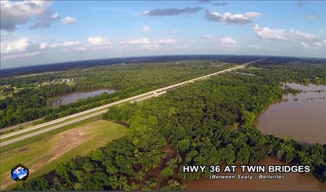
We then went to the twin bridges between Sealy and Bellville that the Dead Man’s Creek flows under. It is usually 2 independent streams but has become one large torrent making its way into the Mill Creek. We also got close shots so that the speed of the water-flow could be seen as well as some awesome aerial footage of this area.
Next it was on to the Brazos River at I-10 as well as the River Ridge Country Club golf course. The Brazos River is flowing along at a very swift current and in areas has gone over its banks. Most notably you can see the area by I-10 and especially how it has overrun onto River Ridge Country Clubs golf course covering it almost completely. The high waters have rendered the course unplayable and it is unclear at what point the waters will subside to allow for play to resume. There has been talk of the gates being opened in Somerville to relieve some of the pressure but, this is still unclear if this is to happen.


